Copyright © 2014-
All Rights Reserved

Updated 02/11/23 7:04 PM
Other Resources
Olympic National Park on the National Parks Service webiste -
Olympic National Park -
Olympic National Park -
Olympic National Park -
Hurricane Ridge -
Sol Duc Hot Springs -
Hoh Rain Forest -
Elwha Valley History -
Lake Cresent -
Olympic Hot Springs -
Olympic Hot Springs -
Olympic National Park Hiking Trails -
Olympic National Park
Washington's Olympic National Park is a place to see glaciers, hike above the clouds, walk along a windswept beach or visit North America's only rain forest.
Washington
2011
About The Park
Olympic National Park is a big, beautiful wilderness situated on the Olympic Peninsula and is practically a suburb of Seattle on the map. I say on the map because, while it looks close, getting to it can require about an 80-
The park’s proximity to Seattle has Olympic in the top ten most visited national parks with over 3 million visitors in 2018. The Olympic Peninsula is also home to eight American Indian tribes. Four of the reservations are located along the Pacific Coast.
The park is over 1400 square miles of a mostly inaccessible, for the average park visitor, interior of mountains, glaciers, rivers and forests. If you want to circumnavigate the park on U.S. highway 101 it is a 300 mile drive. The most commonly visited parts of the park are the North and West sides of the park. This is where most visitors to the park will stay and spend their time. All of the visitor and information centers can be found in these areas.
This is a park that combines rugged coastal areas, two temperate rain forests that get perhaps the most precipitation anywhere in the continental U.S. and a mountainous interior dominated by the 7,965 foot Mount Olympus and the glaciers that emanate from it.
Just outside of Port Angeles is the Olympic National Park Visitor Center which is a good place to start your visit to the park to get the kind of information that will enable you to make the most of your time in the park. The park is big, with many points of interest, and you can easily spend a week exploring all (or most) of what it has to offer. So, if your time is limited, then you have to decide what you have time for and act accordingly.
Areas Of The Park
Hurricane Ridge
This is my favorite part of the park and definitely a must see for any first-
From the visitor center it is an 18-
There is a full service visitor center at the top, elevation 5,242 feet (1,598 m), and a number of hiking trails and scenic lookouts where you can view the beautiful Olympic Mountains. You’re pretty much above the tree line here so the views don’t have many obstructions. In fact sometimes you might be looking down at clouds due to the precipitation that comes off the sea and gets held up by the mountains. The area gets its name from the 75 MPH winds that buffet the area.
Lake Crescent
This is the park’s most visited destination. Here you have a beautiful, unspoiled, glacially carved lake and two lodging options. The lake is cold and deep so it is not a place many people swim in. Boat rentals area available. It is a very scenic place and there are lots of day hiking options from relatively short, easy walks around the lake to hikes up Storm King mountain on steep switchbacks.
Sol Duc Valley
About 40 minutes west of Port Angeles on highway 101 there is the turn off for Sol Duc Road. The road to Sol Duc parallels the Sol Duc River which is a major salmon run. There is a Salmon Cascades Overlook where you can watch the salmon jumping up the falls in late summer. At the end of the road there are some hiking trails, the Sol Duc Falls and a hot spring connected to the Sol Duc Hot Springs Resort. The resort sells day passes to the hot springs. The unusual name come from the Quileute Indian words for sparkling waters.
Hoh Rain Forest
This is about a two hour drive from Port Angeles. The road and is about 20 mile drive from Highway 101 to the Hoh Rainforest visitor center. With about 12 feet of annual rainfall the forest is lush and the trees quite large. The biggest trees can be 300 feet tall (95m) and 23 feet in diameter. Only the giant redwoods and sequoias are bigger. This is the kind of place that has the feeling of being in Jurassic Park. Big trees and giant ferns – all that is missing is the Tyrannosaurus Rex.
The Hoh River valley was formed by glaciers over 10,000 years ago. The glaciers receded and the Hoh River ascends from the glacier on Mount Olympus and runs 50 miles down to the sea to where the Hoh Indian Reservation is. Sadly, much of the area from the park boundary down to the sea was heavily logged over the last century so what is left of the rainforest can only be found in the national park.
Kalaloch and Ruby Beach
If you continue driving south on highway 101 you’ll drive along a narrow strip of the park about 10-
Wildlife
Roosevelt elk, black bears, black-
Humpback whales and sea otters are commonly seen. Grey whales and orcas less so. Viewing is best along the Pacific coast especially at Kalaloch. There’s also 300 species of birds among them bald eagles and northern pygmy owls. There are no poisonous snakes in Olympic National Park.
Lodging
Lake Crescent Lodge
I stayed here and highly recommend it. They have a variety of lodging options. We stayed in a cabin facing the lake just feet from the shoreline. There are also ‘historic Lake Crescent Lodge rooms’ in the main lodge building but they do not have their own bathroom or shower. Lake Crescent is convenient to Elwha, Sol Duc, and Hurricane Ridge. Hoh Rainforest is about an hour drive.
Log Cabin Resort
Located on the northern end of Lake Crescent the resort has lodge rooms, lakeside chalets, newly built modern cabins and rustic cabins (communal restrooms). Some of the new cabins have kitchenettes and two bedrooms which make it ideal for families.
Sol Duc Hot Springs Resort
The resort is modern with the usual amenities. They have cabins, kitchen cabins, duplex cabins and a suite that sleeps 10. Access to the mineral hot springs are included.
Kalaloch Lodge
I stayed here and it was nice and right on the beach. It is the only lodging in this area. Walking along the beach you see giant rock formations just a few yards offshore. The kind of picturesque scenery that you’ve seen before in photos but it’s nice to get up close and personal with them.
If you can’t get reservations in the park itself, Port Angeles has a variety of lodging options for all budgets.
Hiking
Hurricane Hill Trail
This trail is located on Hurricane Ridge, this is a paved trail which is about 1.6 miles (one-
Obstruction Point Trail
Located right at the entrance to the parking area, on your left, is a road that will take you to Obstruction Point. The road is described below but you can walk some of it for an easy (or moderate or strenuous) out-
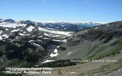
We took the road to the parking area and hiked up Elk Mountain. It was a beautiful hike well above the tree line so the views were magnificent. There was a huge cloud bank below us. It was the end of August and there were still plenty of patches of snow. At one point we could see, well below us, a bear rolling around on one to cool off in the summer heat. We sat and watched and hoped that he wouldn’t notice us even though we were a good distance from him. We knew that when we descended back to the parking area we would be a good deal closer to where he was cooling himself off. Eventually he went on his way and that was the last we saw of him.
Everyone wants to see bears but at a safe distance. Unfortunately the bears go where they want and occasionally you’ll run into them on a hiking trail and that can be more than a bit unnerving. Very rarely do these encounters result in an attack. Bears don’t like people and who can blame them. But keep in mind that you are in bear country so it is wise to read up on bear safety and remember it. Pictures of this hike are in the photo gallery.
A list of hiking trails in the Hurricane Ridge area can be found here.
Marymere Falls
Located in the Lake Crescent area, the hike was an easy 2-
A list of hiking trails in the Lake Crescent area can be found here.
Sol Duc Falls Trail
Located in the Sol Duc area, at the end of the road, just past the Sol Duc Resort, is a 0.8 mile one way trail to Sol Duc Falls. It is an impressive cascade.
A list of hiking trails in the Sol Duc Resort area can be found here.
Elwha Valley
A list of hiking trails in the Elwha Valley can be found here.
Hoh Rainforest
A list of hiking trails in the Hoh Rainforest area can be found here.
Kalaloch Nature Trail
Located in the Kalaloch area, across highway 101 from the Kalaloch Lodge is this short 1-
Other Points of Interest
Elwha Valley
Access to the Elwha Valley is from the Olympic Hot Springs Road which is just a few miles west of the Hurricane Ridge turnoff. There are a number of hiking trails in the area including the 60’ Madison Falls which is a paved 0.1 mile trail from the parking area.
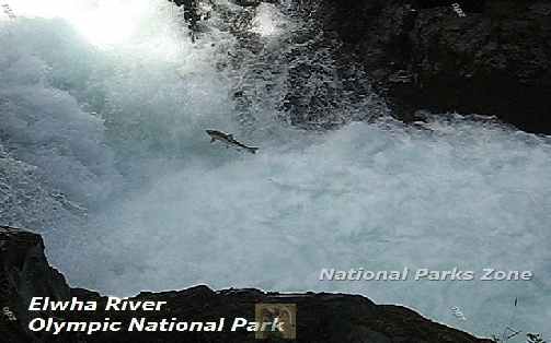
The road follows the Elwha River which was a major salmon run until it the Elwha Dam was built in 1913 followed by the Glines Canyon Dam in 1927. These dams had a marked negative impact on the native Lower Elwha Klallam Tribe. Conservationists had been trying to remove it at least since the 1980’s and in 1992 Congress approved removing both dams and restoring the ecosystem. The Elwha Dam was removed in 2011 and the Glines Dam in 2014. Restoration of the valley ecosystem is ongoing but the salmon have returned. The picture at the top of the page of a jumping salmon was taken In late August.
Olympic Hot Springs
I mention this for informational purposes because it is probably best to avoid it in the summer months. This is a place for a free soak in a far less visited place. Getting to these hot springs requires a 2.5 mile one-
Obstruction Point Road
For the more adventurous there is an 8-
Cape Flattery
If you have time you can take a day trip to Cape Flattery, the northwesternmost point in the contiguous United States, on the very tip of the Olympic Peninsula. The drive is about 80 miles one way from Port Angeles and is a good two hours. State road 112 hugs the coast and the Strait of Juan de Fuca. I drove it from Lake Crescent and it is a slightly shorter drive (65 miles) via state road 113.
Cape Flattery resides on the Makah Indian Reservation at the end of the road. The town on the reservation is at Neah Bay. There’s food, a marina and the Makah Research and Cultural Center. A few miles past the town is Cape Flattery. There’s an easy trail out to an overlook on top of an outcropping where you are looking down at the crashing waves of the sea. Across the strait is Tatoosh Island, a pretty piece of greenery dominated by its sheer cliffs and the lighthouse that sits on it. You can see pictures of this in the photo gallery.
Victoria, British Columbia
Another possible day trip out of Port Angeles it to take the ferry to Victoria, BC on Vancouver Island. Victoria is a beautiful city with restaurants and shops. The ferry takes about 90 minutes. The fare as of 2020 was about $20 per person or $67 for a vehicle and driver one-
Olympic National Park Photo Gallery


Other National Parks and National Monuments Within a Day’s Drive
Since going to either of these national parks would probably have you flying into or out of Seattle the distances to Seattle are listed.
North Cascades National Park With 300 glaciers among its jagged peaks and relatively few visitors it is 157 miles to the northeast. It involves taking a ferry from Port Townsend to Whidbey Island assuming you are staying in the northern part of the park. The alternative is about a 200 mile drive if you go through Seattle. The ferry route is much more relaxing, scenic and you can, if you can time the ferry right, get there faster. If you are coming to North Cascades National Park from Kalaloch then driving through Seattle is a faster way to get there.
North Cascades National Park is about 125 miles northeast of Seattle.
Mount Rainier National Park has a massive glacier covered mountain and the aptly named Paradise Inn and it is about 212 miles to the south and is a 4.5 to 5 hour drive. Seattle to Mount Rainier is about 90 miles.
Mount St. Helens National Volcanic Monument The site of the massive 1980 volcanic eruption is 245 miles south and about a 5 hour drive from Port Angeles. From Kalaloch it is about 230 miles south. From Seattle it is about 190 miles and a 3.5 hour drive.
*N*P*Z*
National Parks Zone